Indicator Ratings | ||||||
|---|---|---|---|---|---|---|
TargetSpecies | KEA | Indicator | Poor | Fair | Good | Very Good |
Westslope Cutthroat Trout | Accessible habitat downstream of Elko Dam | Longest | <25% | 26 – 50% | 51 – 75% | >76% |
Current Status: | 77.53% | |||||
Comments: Indicator rating definitions are based on the consensus decisions of the Planning Team. The current status is based on the CWF Barrier Prioritization Model output, which is current as of April 2026. | ||||||
Current Connectivity Status
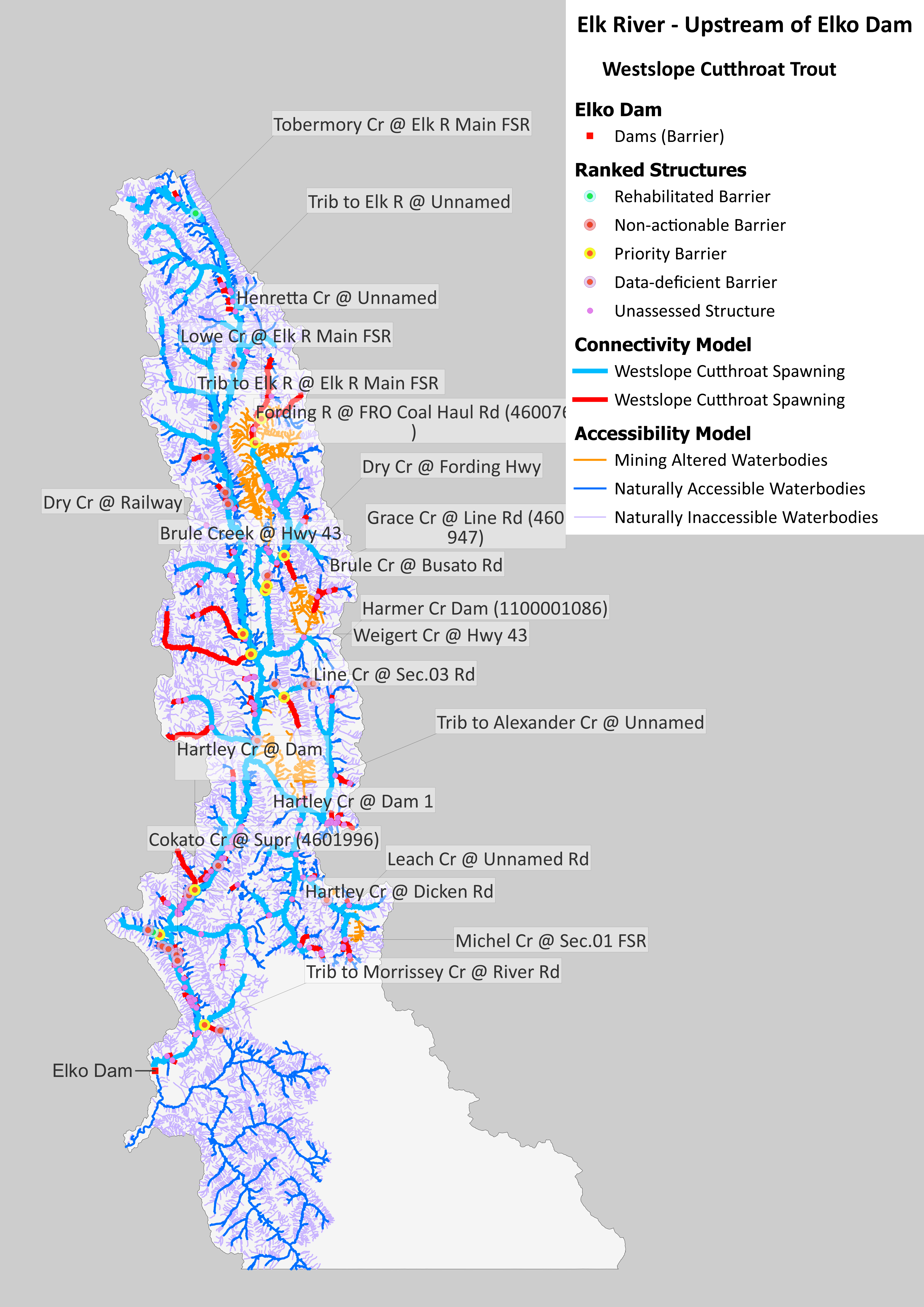
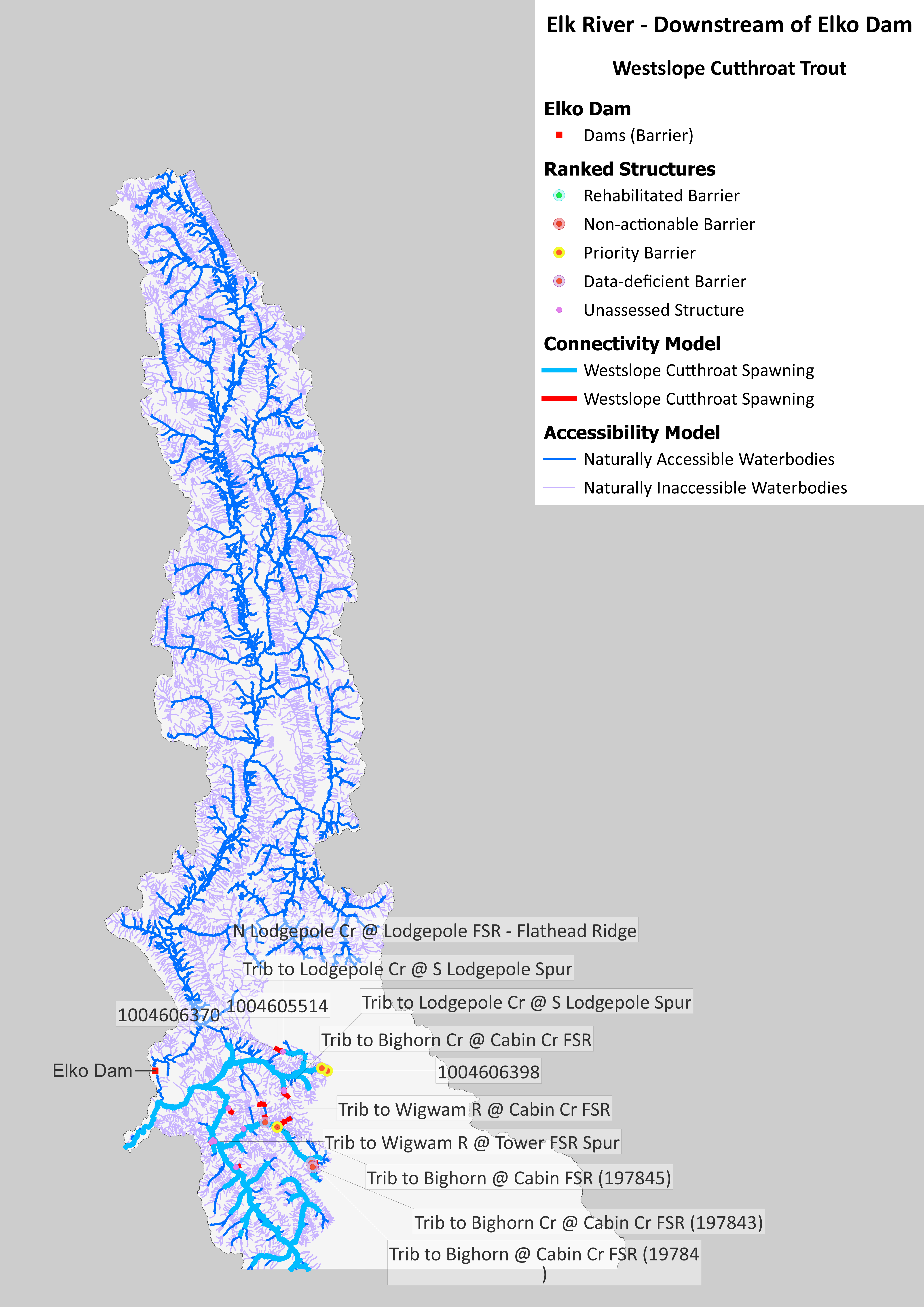
The Planning Team devised two Key Ecological Attributes (KEAs) and associated indicators to assess the current connectivity status of Qukin ?amak?is – Accessible habitat above Elko Dam and Accessible habitat below Elko Dam (Table 4). KEAs are the key aspects of Westslope Cutthroat Trout ecology that are being targeted by this WCRP. The connectivity statuses for the Westslope Cutthroat Trout KEAs were used to establish goals to improve habitat connectivity in the watershed and will be the baseline against which progress is tracked over time.
To support a flexible prioritization framework to identify priority barriers in the watershed, two assumptions are made: 1) any modelled (i.e., the passability status is unknown) or partial barriers are treated as complete barriers to passage and 2) the habitat modelling is binary, it does not assign any habitat quality values. As such, the current connectivity status is refined over time as more data on habitat and barriers are collected.
Indicator Ratings | ||||||
|---|---|---|---|---|---|---|
TargetSpecies | KEA | Indicator | Poor | Fair | Good | Very Good |
Westslope Cutthroat Trout | Accessible habitat downstream of Elko Dam | Longest | <25% | 26 – 50% | 51 – 75% | >76% |
Current Status: | 94.67% | |||||
Comments: Indicator rating definitions are based on the consensus decisions of the Planning Team. The current status is based on the CWF Barrier Prioritization Model output, which is current as of April 2026. | ||||||
In Qukin ?amak?is upstream of Elko Dam, 756.67 km of Westslope Cutthroat Trout habitat are currently connected, 192.15 km are disconnected, and 27.21 km are permanently altered by mining. This means that 77.53% of the 976.03 km of total habitat is connected, and 2.79% of total habitat is permanently altered by mining.
In Qukin ?amak?is downstream of Elko Dam, 208.36 km of Westslope Cutthroat Trout habitat are currently connected, 11.72 km are disconnected, and 0 km are permanently altered by mining. This means that 94.67% of the 220.08 km of total habitat is connected, and 0% of total habitat is permanently altered by mining.
Goals
Goal # | Goal |
|---|---|
1 | By 2031, the Longest Fragment (%) for Westslope Cutthroat Trout will increase from 69% to 83% above the Elko Dam (i.e., reconnect at least 142 km of habitat). |
2 | By 2041, the Longest Fragment (%) for Westslope Cutthroat Trout will increase to 86% above the Elko Dam (i.e., reconnect at least an additional 30 km of habitat). |
3 | By 2031, the Longest Fragment (%) for Westslope Cutthroat Trout will increase from 98% to 99% below the Elko Dam (i.e., reconnect at least 3 km of habitat). |
4 | By 2041, the Longest Fragment (%) for Westslope Cutthroat Trout will not decrease from 99% below the Elko Dam. |
Structure Count
In Qukin ?amak?is upstream of Elko Dam, 216 structures potentially disconnect Westslope Cutthroat Trout habitat. Of these, 15 are identified as barriers in need of rehabilitation (priority barriers), 1 are identified as barriers that do not warrant rehabilitation (non-actionable), and 211 require further field assessment.
In Qukin ?amak?is downstream of Elko Dam, 15 structures potentially disconnect Westslope Cutthroat Trout habitat. Of these, 3 are identified as barriers in need of rehabilitation (priority barriers), 1 are identified as barriers that do not warrant rehabilitation (non-actionable), and 14 require further field assessment.
Maps
Habitat Accumulation Curves
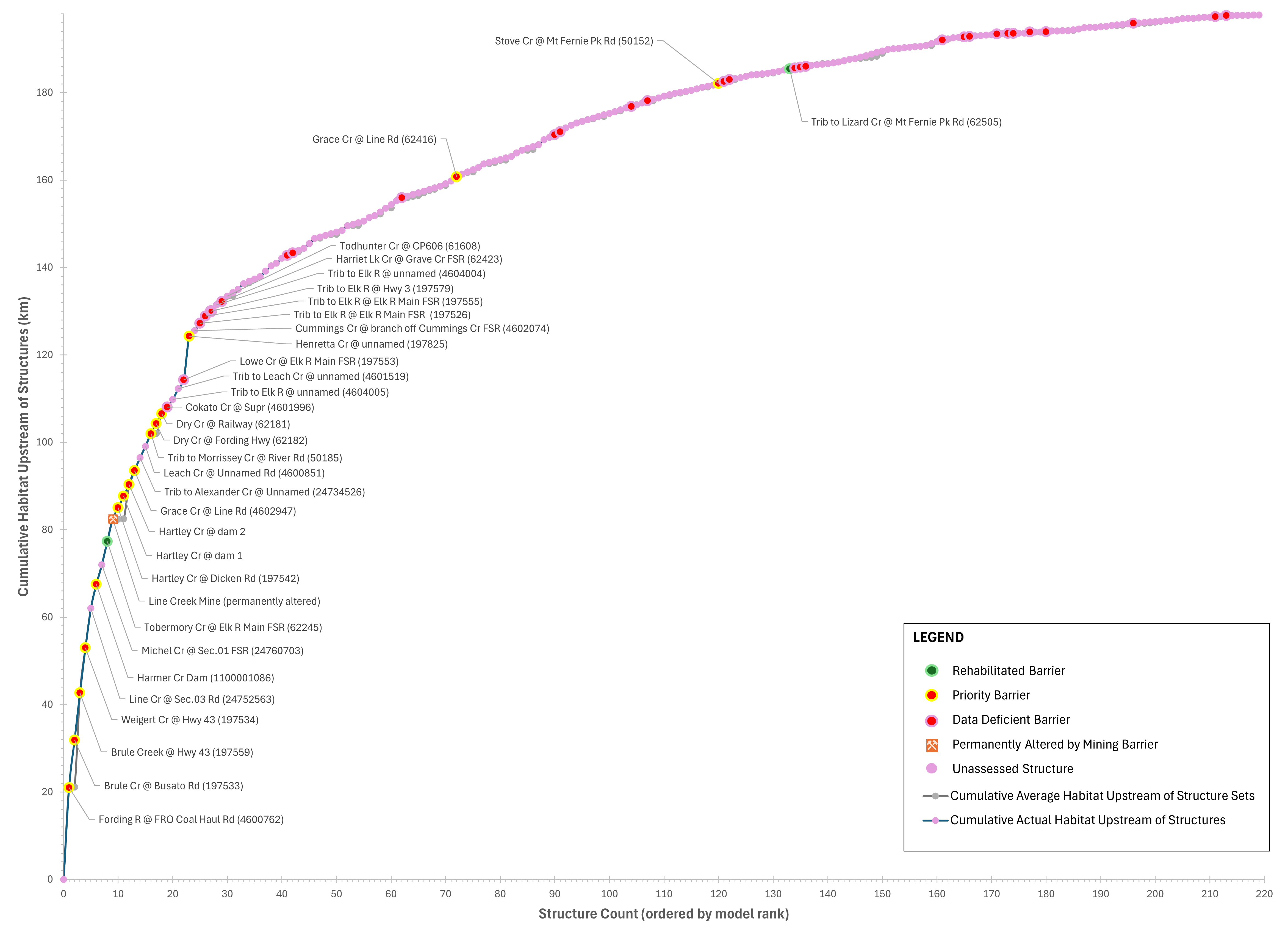
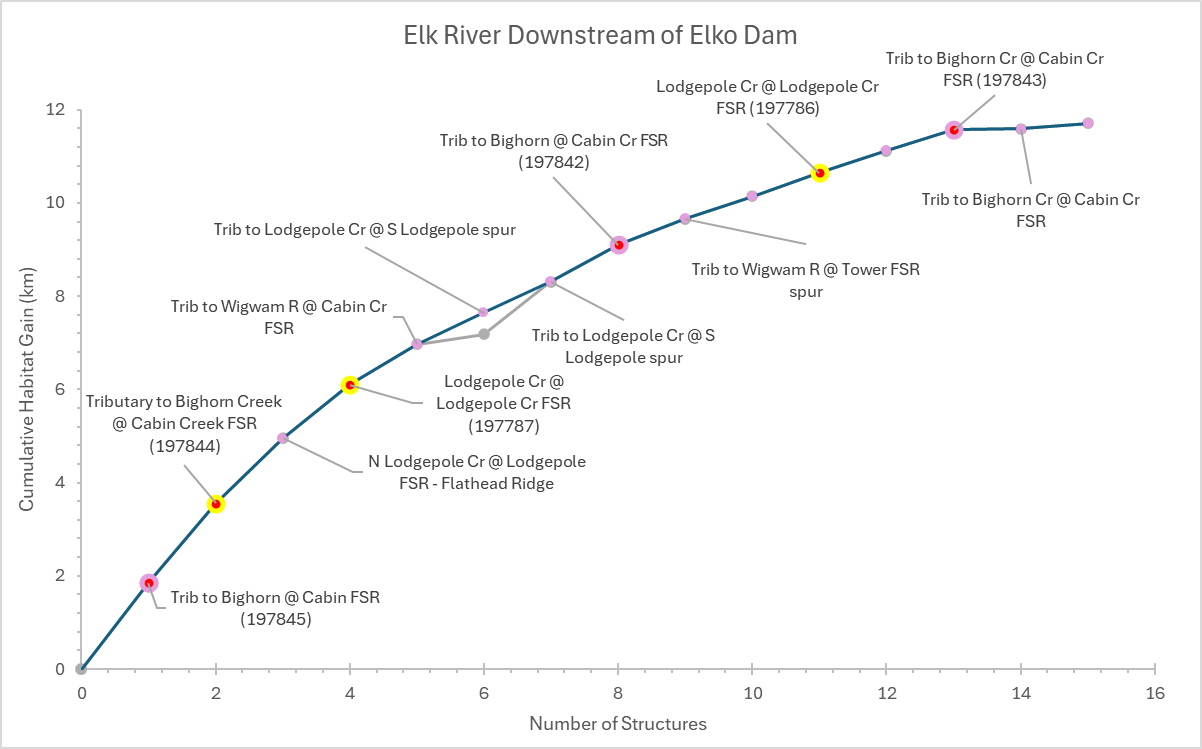
Habitat Accumulation Summary Tables
Barrier ID | Site Name | Watershed Name | Structure Status | Rank Order | Average Habitat Gain (km) |
|---|---|---|---|---|---|
1004600851 | Leach Cr @ Unnamed Rd | ELKR | NULL | 11 | 2.60 |
1004601519 | NULL | ELKR | NULL | 16 | 2.45 |
1004602074 | NULL | ELKR | NULL | 19 | 1.28 |
1004602974 | Grace Cr @ Line Rd (4602947) | ELKR | Priority barrier | 9 | 3.24 |
1004604005 | Trib to Elk R @ unnamed | ELKR | NULL | 15 | 1.74 |
1024734526 | Trib to Alexander Cr @ Unnamed | ELKR | NULL | 10 | 2.94 |
1024752563 | Line Cr @ Sec.03 Rd | ELKR | NULL | 4 | 9.01 |
1024760703 | Michel Cr @ Sec.01 FSR | ELKR | NULL | 6 | 4.49 |
13635d39-ee0f-4d0c-bb9c-9649ac9a5c63 | Harmer Cr Dam (1100001086) | ELKR | Priority barrier | 5 | 5.47 |
197526 | Trib to Elk R @ Elk R Main FSR | ELKR | Data-deficient barrier | 20 | 1.70 |
197533 | Brule Cr @ Busato Rd | ELKR | Priority barrier | 2 | 0.13 |
197534 | Weigert Cr @ Hwy 43 | ELKR | Priority barrier | 3 | 10.32 |
197542 | Hartley Cr @ Dicken Rd | ELKR | Priority barrier | 8 | 0.01 |
197553 | Lowe Cr @ Elk R Main FSR | ELKR | Data-deficient barrier | 17 | 2.01 |
197559 | Brule Creek @ Hwy 43 | ELKR | Priority barrier | 2 | 21.56 |
197825 | Henretta Cr @ unnamed | ELKR | Priority barrier | 18 | 10.00 |
197827 | Fording R @ FRO Coal Haul Rd (4600762) | ELKR | Priority barrier | 1 | 21.01 |
199904 | Cokato Cr @ Supr (4601996) | ELKR | Data-deficient barrier | 14 | 1.53 |
50185 | Trib to Morrissey Cr @ River Rd | ELKR | Priority barrier | 12 | 2.89 |
62181 | Dry Cr @ Railway | ELKR | Priority barrier | 13 | 4.53 |
62182 | Dry Cr @ Fording Hwy | ELKR | Priority barrier | 13 | 0.03 |
62245 | Tobermory Cr @ Elk R Main FSR | ELKR | Rehabilitated barrier | 7 | 5.33 |
98a6d14e-ea75-446a-80e5-8709bf2eb8e9 | Hartley Cr @ dam 1 | ELKR | Priority barrier | 8 | 0.04 |
e86b513c-3dce-4b4a-a49e-e86e4dac935e | Hartley Cr @ dam 2 | ELKR | Priority barrier | 8 | 7.83 |
Barrier ID | Site Name | Watershed Name | Structure Status | Rank Order | Average Habitat Gain (km) |
|---|---|---|---|---|---|
197845 | Trib to Bighorn @ Cabin FSR (197845) | ELKR | Data-deficient barrier | 1 | 1.85 |
197844 | 1004605514 | ELKR | Priority barrier | 2 | 1.71 |
1004601731 | N Lodgepole Cr @ Lodgepole FSR - Flathead Ridge | ELKR | NULL | 3 | 1.39 |
197787 | 1004606370 | ELKR | Priority barrier | 4 | 1.15 |
1004605528 | Trib to Wigwam R @ Cabin Cr FSR | ELKR | NULL | 5 | 0.87 |
1004603632 | Trib to Lodgepole Cr @ S Lodgepole spur | ELKR | NULL | 6 | 0.21 |
1004602683 | Trib to Lodgepole Cr @ S Lodgepole spur | ELKR | NULL | 6 | 1.13 |
197842 | Trib to Bighorn @ Cabin Cr FSR (197842) | ELKR | Data-deficient barrier | 7 | 0.79 |
1004603498 | Trib to Wigwam R @ Tower FSR spur | ELKR | NULL | 8 | 0.56 |
1004603497 | NULL | ELKR | NULL | 9 | 0.48 |
197786 | 1004606398 | ELKR | Priority barrier | 10 | 0.51 |
50175 | NULL | ELKR | NULL | 11 | 0.47 |
197843 | Trib to Bighorn Cr @ Cabin Cr FSR (197843) | ELKR | Data-deficient barrier | 12 | 0.45 |
1004605549 | Trib to Bighorn Cr @ Cabin Cr FSR | ELKR | NULL | 13 | 0.02 |
50177 | NULL | ELKR | NULL | 14 | 0.12 |